Category: Underground Sewage System
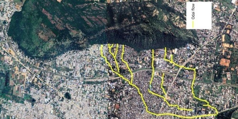
This map traces the natural stormwater flow that begins in the Sanjeevi Hills and travels nearly three kilometres through the heart of Rajapalayam before reaching its main collection point, Periyadhikulam Kanmai. Originating from the headwaters of Sanjeevi Hill, the rainwater follows a traditional odai (channel) path that has historically guided seasonal runoff across the town.
The main channel passes through Malaiyadipatti, moves along T.P. Mills Road, flows past Ambalapuli Bazar and Sankarankovil Mukku, continues through INTUC Nagar, and finally reaches Periyadhikulam Kanmai opposite to New Bus Stand.
This is not a single isolated stream but a networked system. Four sub-odais, or secondary channels, merge into the main flow at different points, steadily increasing the water volume as it moves downstream. Together, these interconnected channels form an important urban drainage corridor, carrying rainwater safely from the hills through the town.
Understanding this natural flow pattern highlights the importance of protecting and maintaining these traditional waterways to ensure effective stormwater management and reduce flooding risks in Rajapalayam.