
Category: Town Planning
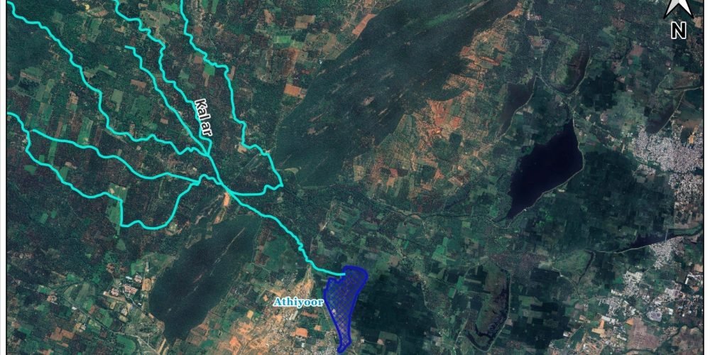
Tucked along the eastern slopes of the Western Ghats, Rajapalayam has, for centuries, depended on a quiet but powerful natural system, runoff water flowing down from the hills. A map tracing this journey reveals a remarkable story: rain that falls in the forested highlands near Ayyanar Kovil begins its descent through rocky channels and seasonal streams, eventually feeding into Athiyoor Kanmai, one of the first and most vital water bodies to receive this flow.
This is not an isolated connection but part of an intricate and time-tested hydrological network. Rajapalayam is home to more than 40 interconnected water bodies – kanmais, tanks, and ponds, many of which rely directly on runoff from the Ayyanar Kovil region. As water moves from one tank to another, it is stored, slowed, and shared, ensuring that even in drier months, communities have access to drinking water. This cascading system reflects traditional wisdom in water management, where every drop is guided, conserved, and reused.
What makes this system especially significant is its resilience. Unlike dependence on a single reservoir or external water source, Rajapalayam’s network distributes risk across multiple storage points. The forests of the Western Ghats act as natural sponges, absorbing rainfall and releasing it gradually. This not only sustains groundwater recharge but also supports biodiversity and stabilises the local climate. The runoff that begins as rainfall in the hills ultimately becomes the lifeline for households, agriculture, and daily life in the city.
For generations, this natural infrastructure has quietly sustained Rajapalayam’s drinking water needs. The map is more than a visual, it is a reminder of how deeply the city is connected to its surrounding landscape. Protecting the Western Ghats, preserving the flow paths, and maintaining the network of water bodies are essential steps to ensure that this legacy continues for years to come.